|
|
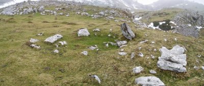
ATAKA XAR trikuharria
| Tipo |
Trikuharria. |
| Zone |
ARALAR. |
| Descubrimiento |
L. Millán San Emeterio (05-04-1981) |
Location |
· Alt.: 1165 m.
· WGS84 42.983757 lat., -1.990142 long.
· ED50 30T X.582440, Y.4759715
· Ubicación exacta (~25m) |
| Cerca |
ATAKAXAR tumulua, Alborta* harrespila, ARRATE ZAR tumulua, ARRATE ZAR etxola hondoa, Etzantza etxola hondoa, Beloki mendia, URDANETA tumulua, IRUZULO 1 hego etxola hondoa, ETZANTZA trikuharria, Algorta etxola hondoa, IRUZULO 2 ipar etxola hondoa, Subezelaigañe mendia, Ttutturre mendia, GAZTELUETA etxola hondoa, BALENKALEKU harrespila, MURKURUKO ARRIPILA etxola hondoa, MURKURUKO ARRIPILA trikuharria, ABATEKO LEPOA tumulua, Illobi 1 - 2 - 3 - 4 - 5 y 6 harrespila, Pallardi mendia, Arriolatz mendia, Illobi 1 harrespila, LERRITZ zutarria, GAZTELUETA hego tumulua, LERRITZ trikuharria, LERRITZ tumulua, Oiarbide mendia, ARAKIL zutarria, ARAKIL etxola hondoa, Oaitzileku etxola hondoa, ATALLORBE tumulua, Mendiaundi mendia, Unako putzua putzua, Txameni mendia, PAGAZELAIETA tumulua, Txurtxur mendia, Amurutxateko Koba leizea, koba, GARRAZTITA trikuharria. |
|
|
  |
 ...
...
©Jose
Fuente: Nafarroako Karta Arkeologikoa (Hilharriak taldea).
Imágenes
 ***
 ****
 ***
 ****
 ***
 ***
 ***
 ***
 ***
 ****
 ***
 ***
 ***
 ***
 ***
|

|


Kokapena zuzendu dut
Kokapenak errore txiki bat zuen, eta tokian bertan hartutako koordenatuen arabera zuzendu dut.